Search
Carrie Bow Cay provides crucial storm-tracking data during Hurricane Nana

Carrie Bow Cay provides crucial storm-tracking data during Hurricane Nana
By Tom Opishinski, Interactive Oceanographics
The morning of September 2, 2020 dawned pleasantly over the Smithsonian’s Carrie Bow Cay (CBC) field station in Belize, but the partly cloudy skies, light winds and 84-degree (29°C) temperatures gave no indication of the threat that had the little island squarely in its crosshairs: Hurricane Nana was approaching from the east.
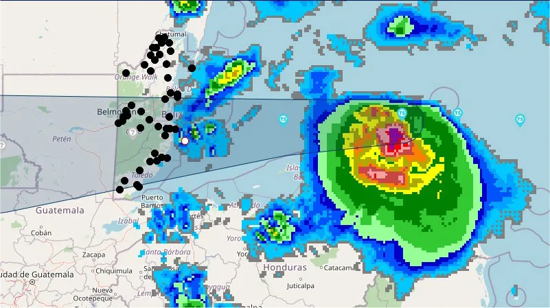
That same morning, meteorologists at the National Meteorological Service of Belize (NMSB) projected that the path of Hurricane Nana would make landfall on the central Belizean coast. Carrie Bow lay just 15 miles offshore of the Belize mainland, and directly in the storm’s path. Despite its ongoing closure due to Covid-19, CBC is equipped with fully automated meteorological & oceanographic monitoring systems which transmit data every 6 minutes.

Recognizing that data from CBC would be invaluable for monitoring early storm conditions and projecting the location of the storm’s landfall, NMSB contacted Tom Opishinski, manager of CBC’s monitoring systems, to check if the system would be operational as the hurricane passed. Opishinski confirmed the system would be operating throughout Nana’s passing--assuming the sensors, communication systems, and the satellite Internet link on Carrie Bow did not sustain damage.
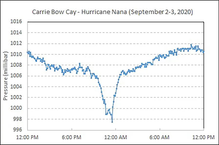
Standard air pressure is 1013.25 millibar; anything below 1000 millibar during a hurricane is significant as it quantifies the hurricane’s strength, and indicates the passing of its center. At 11 a.m., the mercury began to fall, the earliest indication of storm’s approach. By 9:30 p.m., atmospheric pressure had plunged to 1005.7 millibar, and then dipped even lower again at 11:30 p.m., to 997.5 millibar. Just after midnight, pressures again began to rise, indicating the progress of the storm’s center away from the island.

Winds arrived by evening. At 5 p.m., wind speeds and humidity began to increase, and air temperature started falling. A light, steady rainfall began at 6:30 p.m. Wind speeds continued to increase during the evening and, from 10 to 10:54 p.m., blew from the northwest to north-northwest, with sustained speeds between 42-54 miles per hour before quickly dropping off to 22-30 miles per hour from 11 to 11:18 p.m.
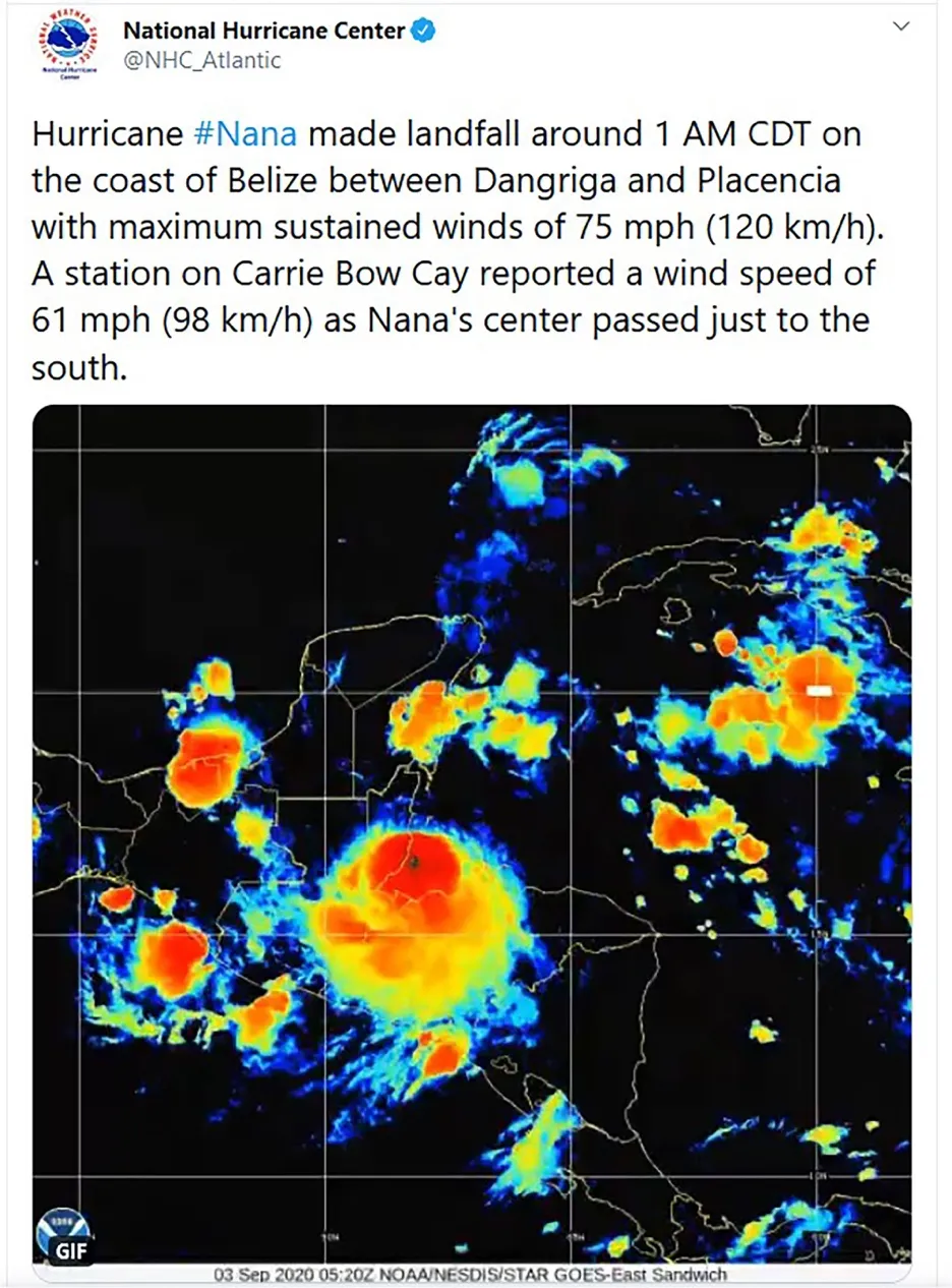
The night’s highest windspeeds came between 11:24 and 11:42 p.m. – all greater than 55 miles per hour, with a maximum of 61.34 miles per hour. The heaviest rainfall also occurred at this time, with 35 mm (about 1.4 inches) of rain falling in a half-hour span. Rainfall ceased at midnight and wind speeds slowed with the last reading above 40 miles per hour measured at 12:30 a.m.
The island maintained communications with NMSB throughout the duration of the storm. The agency used the data to determine if Nana’s eye was passing to the north or south of CBC, as well as to estimate the minimum central pressure. We noted from the initial sequence of data, specifically wind direction, that Nana was maintaining a westerly track, suggesting the eye was slightly north of CBC’s latitude.

The U.S. National Hurricane Center (NHC) also availed themselves of the data flowing from CBC’s sensors. The Belizean weather agency relayed data to the NHC for storm tracking, and to assist a National Oceanic and Atmospheric Administration (NOAA) reconnaissance flight locate the storm’s center and conduct atmospheric measurements.
As the eye passed CBC, indicated by the drop in wind speed and atmospheric pressure, the ensuing change in wind direction suggested Nana’s course had changed to a slight west-southwest path. The eye passed immediately to the south of CBC, with the northwest aspect of the eye wall possibly passing directly over the island.
Carrie Bow Cay’s field station facilities survived the storm with minimal damage—however, Nana did obliterate the island’s picturesque dock-end privy.
--November 2020